
I have read Land Matters by Liz Wells before although I must have somewhat glossed over the final sixth chapter. I didn’t have much recollection of the details of it but by rereading it, I found it one of the most thought-provoking chapters of a very incisive book. Here, Wells relates image and memory, while crucially retaining a link to landscape practice which is useful to me. She likens the extremes of approaches to landscape, image and memory as a ‘fluid seesaw’ – (Wells, 2011), with observational photography and composited, more subjective imagery at the two extremes. Wells importantly expands on her seesaw simile by showing that both sides of the seesaw have elements of the other side.
Wells starts with observational or topographic side of the seesaw, which I will mostly concentrate in this post. Wells feels it is important to look back at the authority the photographic image achieved in the minds of its spectators historically. This was brought about through the visual accuracy that the photographs recorded and the topographic expeditions these surveyors put their cameras up to record: ‘That governments, the military and commercial organisations commissioned photographers to chart the land testifies to belief in the fidelity of the photograph.’ – (Wells, 2011). Even though a photograph was often pre-visualised beforehand (with attention paid to time of day, focus, depth of field) and the views selected by the photographer, ‘a notion of unmediated representation became a part of the idealogical currency of the image, underpinning its documentary authority.’ – (Wells, 2011). For me this rather complicated sentence means that the choices the photographer made regarding the photograph were somewhat shunned in favour of the camera more easily being seen as an unbiased recording device.
Wells identifies two developments in topographic photography: the first being the New Topographics, an exhibition which took place in 1975. The overriding trait of the work on show at the exhibition was that the photograph was detached; with seemingly little input by the photographer with regards to the descriptive properties or artistic influence. However, the photographers still selected the subject matter and this was key because they selected it carefully; it comprised of man-made structures, always quietly observed by the photographer. In my opinion these two factors (the observational tone and the man-made structures) went hand in hand. This is because they suggest the urban locations on show as being rather detached from human beings, although of course they were made by humans and used by humans. This indicates the photographers’ potential intended meaning by selecting these man-made structures and using this banal treatment as one of coolness.
When I look at the New Topographics exhibition I see a factor that led to its (eventual) success. This is the detached, observational tone and the selection of subject matter (man-made structures). This offered a then-unique perspective of America/Europe that the viewers of the exhibition initially struggled to come to terms with. I can understand this difficulty as the aesthetics are quite banal but the subject matter isn’t.
An idea came to me when reading Wells’ description of the New Topographics. What if these factors were reversed so that the tone is much more descriptive with the artistic influence being clearly applied to each shot and also the subject matter is not selected at all? Rather, some kind of system would have to be adopted so that the locations the photographs would take place at are randomly selected. This latter approach reminds me of some forms of psychogeography where the photographer looks on a map for instance and randomly selects points off it. These points are then photographed at the coinciding locations. I have tried using a map with points as a starting point for a project before but I feel it might be more interesting if it was something even more random. Mark Power’s 26 Different Endings (2003-6) springs to mind.
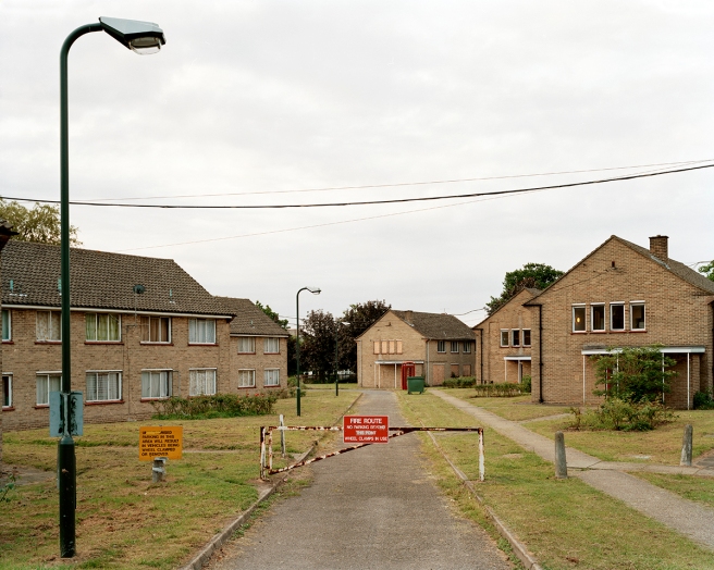
Here, Power looked at an A-Z atlas of London and noticed that the edges of the map were still places but obviously weren’t recorded by the map. He journeyed to the then edges of the map (the A-Z atlas of London has since changed) and recorded the places overlooked with his camera, thus bringing them into life or at least into the image world. I feel this is a clever approach because a lot of people who live in or travel to London take for granted that the A-Z is all encompassing but of course it has to end somewhere. Therefore he utilised this seemingly everyday anomaly to produce a body of work that is photographed with what I feel is a lot of touch and taste, thereby exerting his artistic influence. What gets me is that this feels like a fairly rational strategy for photographing an (admittedly wide) area but Power ends up with a random selection of images which he has put a lot of effort into composing and getting a feel for each place.
I have been thinking for a while how to arrive at something similar for the area of Deptford; possibly to do with its regeneration. I am finding it hard to come up with an alluring strategy that is random and yet makes sense. Instead I have the idea of finding the epicentre of Deptford on a map and then taking random turns based on what a random generator such as a dice told me to take. The dice could also tell me how many streets to walk/which direction to face before I take a photograph so that the selection of subject matter is further randomised.
Alternatively I remembered coming across Charles Booth’s Map Descriptive of London Poverty (1898-9). Here, Booth had marked out on a then-accurate map areas of poverty and conversely areas where the well-to-do lived and those in-between. I feel there could perhaps be a project relating to the maps Booth produced and the poverty map having since changed. If not that then a project looking at the spots on Booth’s Map Descriptive of London Poverty (1898-9) map which do not align accurately with today’s map geographically.
The next topic of Wells’ Land Matters: rephotography was something I’d also considered. I’ve looked at old photographs of Deptford from the lewisham.gov.uk website: https://lewisham.gov.uk/inmyarea/history/local-history/pictures. I had considered appropriating some of these photographs from Deptford and using them as a base for rephotography. This would show how much Deptford had changed over the years if I then photographed the same points in Deptford as the old photographs.
Lastly, all my work for Deptford so far has been conducted via the process of walking. I specifically walked to scout out places where a juxtaposition between old and new Deptford is still evident. This walking was strategic and not at all experiential like the work of Richard Long for example. Perhaps I could wander rather than scout around Deptford with a mind to looking for and recording with photographs the older traces of Deptford. As well as this recording my responses to how I feel while wandering as a kind of flâneur would create a more subjective approach to experiencing Deptford. Potentially this would also evoke memories for me of how I remember Deptford. I have been wondering why I chose Deptford as a subject for my Body of Work (I could have chosen other areas that are local to me). I have come to realise that Deptford for me is everyday and in some ways it is nostalgia for the Deptford I largely remember rather than the recent developments.
References:
Fig. 1 Power, M. (2003-6) L 6 North 26 [Photograph] At: http://bleek-magazine.com/stories/mark-power/ (Accessed on 22/07/2019).
Borough Photos (2019) The Borough in Pictures. At: https://lewisham.gov.uk/inmyarea/history/local-history/pictures (Accessed on 22/07/2019).
Power, M. (2003-6) 26 Different Endings. At: https://www.markpower.co.uk/Photographic-projects/26-DIFFERENT-ENDINGS (Accessed on 22/07/2019).
The London School of Economics and Political Science Library (2016) Map Descriptive of London Poverty, 1898-9. At: https://booth.lse.ac.uk/map/14/-0.1174/51.5064/100/0 (Accessed on 22/07/2019).
Wells, L. (2011) Land Matters, Landscape Photography, Culture and Identity [Google Play Books Edition] From: Google.co.uk (Accessed on 22/07/2019).

4 thoughts on “Liz Wells – Land Matters – Chapter 6”